Sunday, October 08, 2006


Weather Roller Coaster AGAIN, as we warm early in the week and then plummet to much cooler temperatures. Severe Weather, high winds and even frosty temperatures could visit us in the next seven days!

Summary: Life is always crazy, but for me, it has been almost out of control! Is it ever really in control? Anyways, the weather will be a wild one this week. A Polar Vortex will become displaced and form a very strong system that could cause many areas in the Upper plains and around the lakes to see their first real accumulating snows! Not to mention a Severe weather threat and very high winds. This would affect us Thursday. Following the strong Front through here Thursday, temps could actually plummet during the day Friday and end up in the 40's by sunset for some and 30s in the mountains! West facing mountain snows would not be out of the question as well!

Tropics: Tropics are about done now! The likelihood will be that we are done with the Atlantic for the season! Not too bad compared to what was forecasted and what happened last year!

Thanks to all who continue to post to the Forum. http://www.midatlanticweather.com/bb3/

Did You Know? I send this update out semi regularly via email! To get it send and email to midatlanticweather-subscribe@yahoogroups.com I also send a Severe Weather Alert when we need it. To get it mid-atlanticweather-subscribe@yahoogroups.com I am considering a tropical only list as well.

NEED a Great Host! Try Vodahost ! Their plan you cannot beat!!! 24000 MB of space, unlimited domains, unlimited email accounts, unlimited MySqL! HOW MUCH? $7.95 a month!!http://www.vodahost.com/partner/idevaffiliate.php?id=4524

WxAlliance is transforming the way that weather information is available for websites! If you need weather information in a quick and reliable way, WxAlliance will surpass your expectations! http://www.wxalliance.com

Forecast text and graphics from National Weather Service. Mid Atlantic Weather com is not responsible for accuracy of these forecasts and may not be held liable for any damages caused by using this web site. Data may not be current therefore the user agrees to always rely upon official forecast products for their area provided by the National Weather Service.

Saturday, September 16, 2006


Weather Roller Coaster in store next 7 -10 days. Chance of Severe seems possible Tuesday with a big cool down possible mid next week.

Summary: It has been a while as life continues in high speed. With Fall on the horizon we will soon start the "Looking for Winter" series. I am looking for some excited weather folks to help keep this site up to date so send me emails if interested!

The weather will definitely go through some Spring Time swings the next several days! We will warm up nicely until Tuesday. Based on the Tropical moisture feed from Hurricane Lane and such a cool air mass behind the front, I am expecting Tuesday or Wednesday to potentially bring some heavy rains and possible severe. I will be unable to update or even send an alert on the potential so I will very early Alert today!

Wednesday and Thursday could feature a very cool air mass but things will rebound starting next weekend!

Tropics: Tropics remain active, but the US looks to be safe from storms fro now. See the latest info in the Tropical Center .

Thanks to all who continue to post to the Forum. http://www.midatlanticweather.com/bb3/

Did You Know? I send this update out semi regularly via email! To get it send and email to midatlanticweather-subscribe@yahoogroups.com I also send a Severe Weather Alert when we need it. To get it mid-atlanticweather-subscribe@yahoogroups.com I am considering a tropical only list as well.

NEED a Great Host! Try Vodahost ! Their plan you cannot beat!!! 24000 MB of space, unlimited domains, unlimited email accounts, unlimited MySqL! HOW MUCH? $7.95 a month!!http://www.vodahost.com/partner/idevaffiliate.php?id=4524

WxAlliance is transforming the way that weather information is available for websites! If you need weather information in a quick and reliable way, WxAlliance will surpass your expectations! http://www.wxalliance.com

Forecast text and graphics from National Weather Service. Mid Atlantic Weather com is not responsible for accuracy of these forecasts and may not be held liable for any damages caused by using this web site. Data may not be current therefore the user agrees to always rely upon official forecast products for their area provided by the National Weather Service.

Thursday, August 31, 2006

Ernesto coming ashore with almost Hurricane force this evening. It appears that it may head a bit further east than first thought. Still looking at a good 3-6"+ with isolatead 10"+ amounts. The storm will be a bit stronger than first anticipated so some gust winds tomorrow and areas on teh immediate coastal plain. Please monitor these 2 threads for the latest on the Tropical System and the Flooding Threat: Flood Threat: http://www.midatlanticweather.com/bb3/index.php?topic=1244.0 Tropical Storm Thread: http://www.midatlanticweather.com/bb3/index.php?topic=1230.0 Please DO NOT DRIVE THROUGH FLOOD WATERS! The eventual track could be a curve as it runs into a strong blocking high to the north. This High will be the key in precip amounts. I would say that areas would be dealing with a huge winter storm if the time of year was right =) Stay tuned to news and weather outlets for warnings.

Tuesday, August 29, 2006


Serious flooding threat is looming with the remnants of Ernesto and a blocking High Pressure to the north.

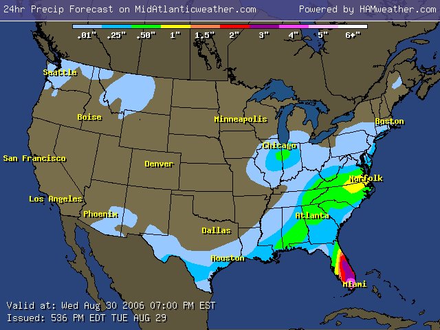
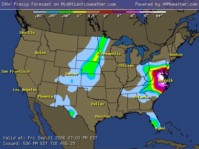
Summary: We are about to have some serious changes to the weather and the threat for heavy flooding is not far behind. I started seeing the possibility a few days ago, but have been too busy to post an update. Based on the trajectory of the Hydrological Prediction Center (HPC) and the model data, a very wet scenario could set up as a dying front allows a weakness to remain over the area and Ernesto comes up the coast SLOWLY. How much rain? Embedded are the latest HPC output which I have through day three, and also the 6 day is posted from the HPC site. Yes, that has a 10"+ area in it! So we will go from a very dry situation to a very very wet one soon!

Tropics: Ernesto is the biggest area of interest for now. Another tropical wave is out in the Atlantic and will be monitored. See more in the Tropical Center .

Thanks to all who continue to post to the Forum. 50 members and growing! http://www.midatlanticweather.com/bb3/

Did You Know? I send this update out semi regularly via email! To get it send and email to midatlanticweather-subscribe@yahoogroups.com I also send a Severe Weather Alert when we need it. To get it mid-atlanticweather-subscribe@yahoogroups.com I am considering a tropical only list as well.

NEED a Great Host! Try Vodahost ! Their plan you cannot beat!!! 24000 MB of space, unlimited domains, unlimited email accounts, unlimited MySqL! HOW MUCH? $7.95 a month! http://www.vodahost.com/partner/idevaffiliate.php?id=4524

WxAlliance is transforming the way that weather information is available for websites! If you need weather information in a quick and reliable way, WxAlliance will surpass your expectations! http://www.wxalliance.com

Forecast text and graphics from National Weather Service. Mid Atlantic Weather com is not responsible for accuracy of these forecasts and may not be held liable for any damages caused by using this web site. Data may not be current therefore the user agrees to always rely upon official forecast products for their area provided by the National Weather Service.

Thursday, August 24, 2006


Severe potential exists today. Nice weather weekend with temps near normal. Dry conditions remain. Tropical Storm Debby appears to be one for the Fishes, but concerns on a disturbance in the Caribbean that could spell Gulf Coast troubles.

Summary: Weather has been on autopilot for a while. Pretty much hot and dry, but not oppressive. Today we have a bit of energy that will swing through at ideal heating times and could cause a few strong to severe storms. We welcome any rains as it has been a dry period. The weekend looks dry with temps near to slightly above norms

Tropics: Tropical Storm Debby may eventually make it to hurricane strength, but should prove to be a therat to ships and not land. Concerns over a disturbance in teh Caribbean that appears to be eventually a threat for teh Gulf states. See more in the Tropical Center .

Thanks to all who continue to post to the Forum. http://www.midatlanticweather.com/bb3/

Did You Know? I send this update out semi regularly via email! To get it send and email to midatlanticweather-subscribe@yahoogroups.com I also send a Severe Weather Alert when we need it. To get it mid-atlanticweather-subscribe@yahoogroups.com I am considering a tropical only list as well.

NEED a Great Host! Try Vodahost ! Their plan you cannot beat!!! 24000 MB of space, unlimited domains, unlimited email accounts, unlimited MySqL! HOW MUCH? $7.95 a month! http://www.vodahost.com/partner/idevaffiliate.php?id=4524

WxAlliance is transforming the way that weather information is available for websites! If you need weather information in a quick and reliable way, WxAlliance will surpass your expectations! http://www.wxalliance.com

Forecast text and graphics from National Weather Service. Mid Atlantic Weather com is not responsible for accuracy of these forecasts and may not be held liable for any damages caused by using this web site. Data may not be current therefore the user agrees to always rely upon official forecast products for their area provided by the National Weather Service.

Wednesday, August 09, 2006


What a difference a week can make in weather! Nice day on tap. Slight chance of Storms tomorrow and Friday, amazing weekend possible! Tropics are quiet!

Summary: Awesome streak in the weather to continue with a slight interruption tomorrow and Friday. Temperatures this morning were amazing here in northern Virginia! 50's were present in many rural areas of Northern Virginia and Maryland! Tomorrow afternoon and Friday a front will be approaching. The approach should bump temperatures to around 90 and up tea humidity a bit. But, this sets the stage for a weekend in the 70s and low 80s for many! AMAZING!

Tropics: Tropics are active but conditions are proving volatile for Tropical Storm formation. This prompted a lowering in the number of storms predicted for the year by the NWS. For more info go to the Tropical Center .

Thanks to all who continue to post to the Forum. http://www.midatlanticweather.com/bb3/

Did You Know? I send this update out semi regularly via email! To get it send and email to midatlanticweather-subscribe@yahoogroups.com I also send a Severe Weather Alert when we need it. To get it mid-atlanticweather-subscribe@yahoogroups.com I am considering a tropical only list as well.

NEED a Great Host! Try Vodahost ! Their plan you cannot beat!!! 24000 MB of space, unlimited domains, unlimited email accounts, unlimited MySqL! HOW MUCH? $7.95 a month! http://www.vodahost.com/partner/idevaffiliate.php?id=4524

WxAlliance is transforming the way that weather information is available for websites! If you need weather information in a quick and reliable way, WxAlliance will surpass your expectations! http://www.wxalliance.com

Forecast text and graphics from National Weather Service. Mid Atlantic Weather com is not responsible for accuracy of these forecasts and may not be held liable for any damages caused by using this web site. Data may not be current therefore the user agrees to always rely upon official forecast products for their area provided by the National Weather Service.

Thursday, August 03, 2006


HEAT SHOULD BECOME LESS TOMORROW! STILL REALLY HOT TODAY! TROPICAL STORM CHRIS IS LIKELY TO DISSIPATE! TROPICS COULD GET ACTIVE AGAIN SOON! A COOLER WEEKEND DOES NOT MEAN REALLY COOL AIR! SEVERE STORMS POSSIBLE TODAY, BETTER CHANCE TOMORROW!

Summary: Dangerous heat on tap again today! Highs approaching 100 with heat indexes up to 110 degrees. As a front approaches isolated storms could fire today and will likely be more widespread tomorrow. Isolated severe threat is there today and more possible tomorrow. Temperatures tomorrow should cool to the lower 90s and the upper 80s to lower 90s this weekend! Typical heat, verses the absurd heat of the last several days!

Tropics: Tropical Storm Chris did really well the last 2 days, but has almost dissipated as of this morning. I think he may be gone. The Tropics should remain active! See the latest info in the Tropical Center .

Thanks to all who continue to post to the Forum. http://www.midatlanticweather.com/bb3/

Did You Know? I send this update out semi regularly via email! To get it send and email to midatlanticweather-subscribe@yahoogroups.com I also send a Severe Weather Alert when we need it. To get it mid-atlanticweather-subscribe@yahoogroups.com I am considering a tropical only list as well.

NEED a Great Host! Try Vodahost ! Their plan you cannot beat!!! 24000 MB of space, unlimited domains, unlimited email accounts, unlimited MySqL! HOW MUCH? $7.95 a month!!http://www.vodahost.com/partner/idevaffiliate.php?id=4524

WxAlliance is transforming the way that weather information is available for websites! If you need weather information in a quick and reliable way, WxAlliance will surpass your expectations! http://www.wxalliance.com

Forecast text and graphics from National Weather Service. Mid Atlantic Weather com is not responsible for accuracy of these forecasts and may not be held liable for any damages caused by using this web site. Data may not be current therefore the user agrees to always rely upon official forecast products for their area provided by the National Weather Service.

Monday, July 31, 2006


HEAT THREAT HAS MATERIALIZED! Break aappears possible Friday into the Weekend! TROPICS ARE SHOWING INCREASED THREAT!

Summary: Dangerous heat on tap the next several days with many areas breaking the 100 degree mark! Thursday could hold a heat breaker if a front can push its way through the heat ridge it may also trigger strong storms! Isolated storms today could be locally severe! Concerned that it may have a hard chance, but could be aided by tropical Developments

Tropics: Tropics Are Now really heating up as the pattern in the Atlantic is undergoing a big change!. See The Tropical Forum and see the latest info in the Tropical Center .

Thanks to all who continue to post to the Forum. http://www.midatlanticweather.com/bb3/

Did You Know? I send this update out semi regularly via email! To get it send and email to midatlanticweather-subscribe@yahoogroups.com I also send a Severe Weather Alert when we need it. To get it mid-atlanticweather-subscribe@yahoogroups.com I am considering a tropical only list as well.

NEED a Great Host! Try Vodahost ! Their plan you cannot beat!!! 24000 MB of space, unlimited domains, unlimited email accounts, unlimited MySqL! HOW MUCH? $7.95 a month!!http://www.vodahost.com/partner/idevaffiliate.php?id=4524

WxAlliance is transforming the way that weather information is available for websites! If you need weather information in a quick and reliable way, WxAlliance will surpass your expectations! http://www.wxalliance.com

Forecast text and graphics from National Weather Service. Mid Atlantic Weather com is not responsible for accuracy of these forecasts and may not be held liable for any damages caused by using this web site. Data may not be current therefore the user agrees to always rely upon official forecast products for their area provided by the National Weather Service.

Friday, July 28, 2006


THREAT FOR HEAT WAVE CONTINUES! Severe Storms Possible Today! Hot and Humid Conditions to persist the next week with highs pretty much in the 90's! Tropics are now showing signs of development from Cape Verde system. Strong suspicions of first hurricane of the season!

Summary: Continued support showing that early next week highs will be at least in the mid and upper 90's with high humidity. Expecting a string of heat advisories!

Severe Weather appears possible today as scattered thunderstorms visit the area. High winds, heavy rains, and small hail are possible. Otherwise temps will remain in the 90's with chances of afternoon and evening thunderstorms through the next 7 days. Mountains will obviously see slightly cooler temps and have a slightly better chance at storms.

Tropics: Tropics now show the signs of the First Cape Verde system of the season. Interests should monitor the situation as long term models do show the potential of an east coast threat. This is so far out it is just something to watch for now. See this thread in the forum. See the latest info in the Tropical Center .

Thanks to all who continue to post to the Forum. http://www.midatlanticweather.com/bb3/

Did You Know? I send this update out semi regularly via email! To get it send and email to midatlanticweather-subscribe@yahoogroups.com I also send a Severe Weather Alert when we need it. To get it mid-atlanticweather-subscribe@yahoogroups.com I am considering a tropical only list as well.

NEED a Great Host! Try Vodahost ! Their plan you cannot beat!!! 24000 MB of space, unlimited domains, unlimited email accounts, unlimited MySqL! HOW MUCH? $7.95 a month!!http://www.vodahost.com/partner/idevaffiliate.php?id=4524

WxAlliance is transforming the way that weather information is available for websites! If you need weather information in a quick and reliable way, WxAlliance will surpass your expectations! http://www.wxalliance.com

Forecast text and graphics from National Weather Service. Mid Atlantic Weather com is not responsible for accuracy of these forecasts and may not be held liable for any damages caused by using this web site. Data may not be current therefore the user agrees to always rely upon official forecast products for their area provided by the National Weather Service.

Thursday, July 27, 2006


INCREASED CONCERN OF SERIOUS HEAT EARLY NEXT WEEK! Otherwise a M.O.T.S. Forecast. It is summer and we are in the repeat pattern of Hazy, Hot, and Humid with chances of afternoon storms! Pattern appears this way for the next 7 days

Summary: More of the same (MOTS) weather is here to stay for a while! There has been some increased model support and concern of a serious set of hot days next week. It is possible we could hit the 100 degree mark or higher! Otherwise temps will remain in the upper 80's verses many days in the low to mid 90's. This is typical summer weather, especially when we have the Bermuda High in place. Today's weather may be interrupted by a few thunderstorms... Tomorrow, has a better chance. The weekend stays hot with a little less of a chance! Not much more to go on here!

By the way.. check out http://wwwif you have not in a while. Tropical Center has been updated and will be updated A LOT MORE in the next few weeks! Also, we have begun the photo gallery which you can email me pictures at wxmanATmidatlanticweather.com (replace the AT with the @ symbol) Many updated links have improved speed and information available. The menu alone has over 250 links in it! Just added Marine weather forecasts!

Tropics: Tropics remain quiet for now! See the latest info in the Tropical Center .

Thanks to all who continue to post to the Forum. http://www.midatlanticweather.com/bb3/

Did You Know? I send this update out semi regularly via email! To get it send and email to midatlanticweather-subscribe@yahoogroups.com I also send a Severe Weather Alert when we need it. To get it mid-atlanticweather-subscribe@yahoogroups.com I am considering a tropical only list as well.

NEED a Great Host! Try Vodahost ! Their plan you cannot beat!!! 24000 MB of space, unlimited domains, unlimited email accounts, unlimited MySqL! HOW MUCH? $7.95 a month!!http://www.vodahost.com/partner/idevaffiliate.php?id=4524

WxAlliance is transforming the way that weather information is available for websites! If you need weather information in a quick and reliable way, WxAlliance will surpass your expectations! http://www.wxalliance.com

Forecast text and graphics from National Weather Service. Mid Atlantic Weather com is not responsible for accuracy of these forecasts and may not be held liable for any damages caused by using this web site. Data may not be current therefore the user agrees to always rely upon official forecast products for their area provided by the National Weather Service.


M.O.T.S. Forecast. It sis summer and we are in the repeat pattern of Hazy, Hot, and Humid with chances of afternoon storms! Pattern appears this way for the next 7 days

Summary: More of the same (MOTS) weather is here to stay for the next 7 days or more. The only differences will be some days in the mid and upper 80's verses many days in the low to mid 90's. This is typical summer weather, especially when we have the Bermuda High in place. Today's weather may be interrupted by a few thunderstorms... Tomorrow, has a better chance. The weekend stays hot with a little less of a chance! Not much more to go on here!

By the way.. check out http://www,midatlanticweather.comif you have not in a while. Tropical Center has been updated and will be updated A LOT MORE in the next few weeks! Also, we have begun the photo gallery which you can email me pictures at wxmanATmidatlanticweather.com (replace the AT with the @ symbol) Many updated links have improved speed and information available. The menu alone has over 250 links in it! Just added Marine weather forecasts!

Tropics: Tropics remain quiet for now! See the latest info in the Tropical Center .

Thanks to all who continue to post to the Forum. http://www.midatlanticweather.com/bb3/

Did You Know? I send this update out semi regularly via email! To get it send and email to midatlanticweather-subscribe@yahoogroups.com I also send a Severe Weather Alert when we need it. To get it mid-atlanticweather-subscribe@yahoogroups.com I am considering a tropical only list as well.

NEED a Great Host! Try Vodahost ! Their plan you cannot beat!!! 24000 MB of space, unlimited domains, unlimited email accounts, unlimited MySqL! HOW MUCH? $7.95 a month!!http://www.vodahost.com/partner/idevaffiliate.php?id=4524

WxAlliance is transforming the way that weather information is available for websites! If you need weather information in a quick and reliable way, WxAlliance will surpass your expectations! http://www.wxalliance.com

Forecast text and graphics from National Weather Service. Mid Atlantic Weather com is not responsible for accuracy of these forecasts and may not be held liable for any damages caused by using this web site. Data may not be current therefore the user agrees to always rely upon official forecast products for their area provided by the National Weather Service.
Wednesday, July 26, 2006


Tropics remain relatively Calm! Hotter conditions with Humidity returns to all the region today. Typical late day Thunderstorms. More numerous thunderstorms possible later this week with seasonal temps

Summary: Typical Summertime weather as the Bermuda High starts cranking up the humidity and the the temps stay in the upper 80's and Low 90's. With this comes the typical risk of afternoon and evening thunderstorms. The chances are relatively low today, increase tomorrow, and peak on Friday. A chance remains this weekend and I again have some concern that some areas could see some heavy rainfalls, but it will not be widespread. Otherwise, not much going on here!

By the way.. check out http://www,midatlanticweather.comif you have not in a while. Tropical Center has been updated and will be updated A LOT MORE in the next few weeks! Also, we have begun the photo gallery which you can email me pictures at wxmanATmidatlanticweather.com (replace the AT with the @ symbol) Many updated links have improved speed and information available. The menu alone has over 250 links in it! Just added Marine weather forecasts!

Tropics: Tropics remain quiet for now! See the latest info in the Tropical Center .

Thanks to all who continue to post to the Forum. http://www.midatlanticweather.com/bb3/

Did You Know? I send this update out semi regularly via email! To get it send and email to midatlanticweather-subscribe@yahoogroups.com I also send a Severe Weather Alert when we need it. To get it mid-atlanticweather-subscribe@yahoogroups.com I am considering a tropical only list as well.

Great Host! Vodahost ! A plan you cannot beat!!! 24000 MB of space, unlimited domains, unlimited email accounts, unlimited MySqL!http://www.vodahost.com/partner/idevaffiliate.php?id=4524

WxAlliance is transforming the way that weather information is available for websites! If you need weather information in a quick and reliable way, WxAlliance will surpass your expectations! http://www.wxalliance.com

Forecast text and graphics from National Weather Service. Mid Atlantic Weather com is not responsible for accuracy of these forecasts and may not be held liable for any damages caused by using this web site. Data may not be current therefore the user agrees to always rely upon official forecast products for their area provided by the National Weather Service.

Saturday, July 22, 2006


Storms will likely fire across the region today causing locally very heavy rains. Storms may fire again tomorrow, but not as widespead. Calmer weather likely from Monday through Wednesday with seasonal temperatures.

Summary: Threat remains that thunderstorms could drop 2 inches or more of rain in local areas causing flooding concerns. Pennsylvania seems better situated for flooding rains today. Severe weather also is possible with thunderstorms as high winds would be the biggest threat. Dryer and seasonal temperatures return early next week

By the way.. check out http://www,midatlanticweather.comif you have not in a while. Tropical Center has been updated and will be updated A LOT MORE in the next few weeks! Also, we have begun the photo gallery which you can email me pictures at wxmanATmidatlanticweather.com (replace the AT with the @ symbol) Many updated links have improved speed and information available. The menu alone has over 250 links in it! Just Added an accumulated precipitation plugin! Very cool stuff!

Tropics: Acitivity has really died down. There is a tropical wave that has some chance of making it into the Caribbean in the next few days. This COULD be the first wave that made it from Africa to storm status. Not much other activity remains for the time being. See the latest info in the NEWLY UPDATED Tropical Center .

Thanks to all who continue to post to the Forum. http://www.midatlanticweather.com/bb3/

Did You Know? I send this update out semi regularly via email! To get it send and email to midatlanticweather-subscribe@yahoogroups.com I also send a Severe Weather Alert when we need it. To get it mid-atlanticweather-subscribe@yahoogroups.com I am considering a tropical only list as well.

Great Host! Vodahost ! A plan you cannot beat!!! 24000 MB of space, unlimited domains, unlimited email accounts, unlimited MySqL!http://www.vodahost.com/partner/idevaffiliate.php?id=4524

WxAlliance is transforming the way that weather information is available for websites! If you need weather information in a quick and reliable way, WxAlliance will surpass your expectations! http://www.wxalliance.com

Forecast text and graphics from National Weather Service. Mid Atlantic Weather com is not responsible for accuracy of these forecasts and may not be held liable for any damages caused by using this web site. Data may not be current therefore the user agrees to always rely upon official forecast products for their area provided by the National Weather Service.

Friday, July 21, 2006


Tropical Storm Beryl moving away from the New England Coast after actually making landfall! It appears that we have a good rainfall in between today and Sunday. The Severe threat today is especially in the piedmont and areas eastward, but really encompasses the whole area tomorrow. Dryer conditions with seasonal temps returning early next week.

Summary: Still seeing a good threat for a soaking rain, especially in thunderstorms, as the amount of moisture in the air is very high. Flooding concerns are mainly Maryland and Pennsylvania as some totals could approach 3 inches or more in these regions. Severe weather also appears possible today, especially the piedmont areas and eastward, and tomorrow area wide. Dryer and seasonal temperatures return early next week

By the way.. check out http://www,midatlanticweather.comif you have not in a while. Tropical Center has been updated and will be updated A LOT MORE in the next few weeks! Also, we have begun the photo gallery which you can email me pictures at wxmanATmidatlanticweather.com (replace the AT with the @ symbol) Many updated links have improved speed and information available. The menu alone has over 250 links in it! Just added Marine weather forecasts!

Tropics: Tropical Storm Beryl is heading off the New England coast and not much other activity remains for the time being. See the latest info in the Tropical Center .

Thanks to all who continue to post to the Forum. http://www.midatlanticweather.com/bb3/

Did You Know? I send this update out semi regularly via email! To get it send and email to midatlanticweather-subscribe@yahoogroups.com I also send a Severe Weather Alert when we need it. To get it mid-atlanticweather-subscribe@yahoogroups.com I am considering a tropical only list as well.

Great Host! Vodahost ! A plan you cannot beat!!! 24000 MB of space, unlimited domains, unlimited email accounts, unlimited MySqL!http://www.vodahost.com/partner/idevaffiliate.php?id=4524

WxAlliance is transforming the way that weather information is available for websites! If you need weather information in a quick and reliable way, WxAlliance will surpass your expectations! http://www.wxalliance.com

Forecast text and graphics from National Weather Service. Mid Atlantic Weather com is not responsible for accuracy of these forecasts and may not be held liable for any damages caused by using this web site. Data may not be current therefore the user agrees to always rely upon official forecast products for their area provided by the National Weather Service.

Thursday, July 20, 2006


Tropical Storm Beryl nearing the New England Coast. Increasing threat of Excessive Rainfall event for this coming weekend as well as some Severe Weather!

Summary: A combination of a stalling front with a vigorous upper level support, and more tropical moisture could spell quite a heavy rain event this weekend. Areas could receive in excess of 3 inches which again raises the threat for flooding rains! This may also mean Severe Weather!

By the way.. check out http://www.midatlanticweather.com if you have not in a while. Tropical Center has been updated and will be updated A LOT MORE in the next few weeks! Also, we have begun the photo gallery which you can email me pictures at wxmanATmidatlanticweather.com (replace the AT with the @ symbol) Many updated links have improved speed and information available. The menu alone has over 250 links in it! Just added Marine weather forecasts!

Tropics: Tropical Storm Beryl jogged westward overnight and is moving extremely slowly this morning. New England has Tropical Storm Warnings posted. See the latest info in the Tropical Center . The Tropics could really start to show some activity in about a week from what I can tell. I am hoping to have the Tropical area on Mid Atlantic Weather refined even more and the new tropical site up in the next 2 weeks! A lot of Satellite shots. The new Hamweather Plugin was recently posted! Should be great!

Thanks to all who continue to post to the Forum. The community has grown to 45 members. Please come and add flooding stories and pictures to the new Floods of 2006 topic: http://www.midatlanticweather.com/bb3/

Did You Know? I send this update out semi regularly via email! To get it send and email to midatlanticweather-subscribe@yahoogroups.com I also send a Severe Weather Alert when we need it. To get it mid-atlanticweather-subscribe@yahoogroups.com I am considering a tropical only list as well.

Great Host! Vodahost ! A plan you cannot beat!!! 24000 MB of space, unlimited domains, unlimited email accounts, unlimited MySqL! http://www.vodahost.com?a_aid=0048a41a

WxAlliance is transforming the way that weather information is available for websites! If you need weather information in a quick and reliable way, WxAlliance will surpass your expectations! http://www.wxalliance.com

Forecast text and graphics from National Weather Service. Mid Atlantic Weather com is not responsible for accuracy of these forecasts and may not be held liable for any damages caused by using this web site. Data may not be current therefore the user agrees to always rely upon official forecast products for their area provided by the National Weather Service.

Tuesday, July 18, 2006


Very Hot Conditions Remain! Also, the air quality has deteriorated so please be careful. The good news is that the heat appears to subside more than I had originally thought, but not as quickly in the southern half of the region. Tropical troubles?

Summary: Heat advisories are posted again today with good reason! Highs will again top out near 100, and heat index values 105 - 110! A frontal system will slip through slowly first cooling the north into the upper 80s tomorow and then knocking the heat back to the lower 90s Thursday in the Southern areas. There is a possibility of an isolated storm which may become severe with such heat! I will monitor. Air Quality will be an issue today as well. See the Air Quality Maps.

By the way.. check out http://www.midatlanticweather.com if you have not in a while. Tropical Center has been updated and will be updated A LOT MORE in the next few weeks! Also, we have begun the photo gallery which you can email me pictures at wxmanATmidatlanticweather.com (replace the AT with the @ symbol) Many updated links have improved speed and information available. The menu alone has over 250 links in it! Just added Marine weather forecasts!

Tropics: There is a low off the New England area that shows some development, but it is headed to colder waters. Also, a low of the SE coast could develop. See the latest info in the Tropical Center and also see latest models on the system here and the satellites on it here. This system is forecast to possibly strengthen. The Tropics could really start to show some activity in about a week from what I can tell. I am hoping to have the Tropical area on Mid Atlantic Weather refined even more and the new tropical site up in the next 2 weeks! A lot of Satellite shots. The new Hamweather Plugin was recently posted! Should be great!

Thanks to all who continue to post to the Forum. The community has grown to 45 members. Please come and add flooding stories and pictures to the new Floods of 2006 topic: http://www.midatlanticweather.com/bb3/

Did You Know? I send this update out semi regularly via email! To get it send and email to midatlanticweather-subscribe@yahoogroups.com I also send a Severe Weather Alert when we need it. To get it mid-atlanticweather-subscribe@yahoogroups.com I am considering a tropical only list as well.

Great Host! Vodahost ! A plan you cannot beat!!! 24000 MB of space, unlimited domains, unlimited email accounts, unlimited MySqL! http://www.vodahost.com?a_aid=0048a41a

WxAlliance is transforming the way that weather information is available for websites! If you need weather information in a quick and reliable way, WxAlliance will surpass your expectations! http://www.wxalliance.com

Forecast text and graphics from National Weather Service. Mid Atlantic Weather com is not responsible for accuracy of these forecasts and may not be held liable for any damages caused by using this web site. Data may not be current therefore the user agrees to always rely upon official forecast products for their area provided by the National Weather Service.

Monday, July 17, 2006


VERY VERY HOT! This will be a very hot spell so just get ready to experience very hot conditions! The POOL is your friend this week!

Summary: As I expected, many areas are under Heat Advisories today and many will be as well tomorrow, though it is possible some Thunderstorms could make the day less oppressive tomorrow, but the humidity may offset that. See the Heat Index Outlook here! The forecast only calls to the low 90s by the weekend so we remain HOT!

By the way.. check out http://www.midatlanticweather.com if you have not in a while. Tropical Center has been updated and will be updated A LOT MORE in the next few weeks! Also, we have begun the photo gallery which you can email me pictures at wxmanATmidatlanticweather.com (replace the AT with the @ symbol) Many updated links have improved speed and information available. The menu alone has over 250 links in it! Just added Marine weather forecasts!

Tropics: There is a low off the New England area that shows some development, but it is headed to colder waters. Also, a low of the SE coast could develop. See the latest info in the Tropical Center! The Tropics should really start to show some activity in about a week from what I can tell. I am hoping to have the Tropical area refined even more and the new tropical site up in the next 2 weeks! A lot of Satellite shots. The new Hamweather Plugin was recently posted! Should be great!

Thanks to all who continue to post to the Forum. The community has grown to 45 members. Please come and add flooding stories and pictures to the new Floods of 2006 topic: http://www.midatlanticweather.com/bb3/

Did You Know? I send this update out semi regularly via email! To get it send and email to midatlanticweather-subscribe@yahoogroups.com I also send a Severe Weather Alert when we need it. To get it mid-atlanticweather-subscribe@yahoogroups.com I am considering a tropical only list as well.

Great Host! Vodahost ! A plan you cannot beat!!! 24000 MB of space, unlimited domains, unlimited email accounts, unlimited MySqL! http://www.vodahost.com?a_aid=0048a41a

WxAlliance is transforming the way that weather information is available for websites! If you need weather information in a quick and reliable way, WxAlliance will surpass your expectations! http://www.wxalliance.com

Forecast text and graphics from National Weather Service. Mid Atlantic Weather com is not responsible for accuracy of these forecasts and may not be held liable for any damages caused by using this web site. Data may not be current therefore the user agrees to always rely upon official forecast products for their area provided by the National Weather Service.

Sunday, July 16, 2006


VERY VERY HOT! This will be a very hot spell so just get ready to experience very hot conditions! The POOL is your friend this week!

Summary: This is the dog days of summer! Highs will surpass the 100 degree mark in many locations, especially Monday and Tuesday. A Slight cooling to the lower 90s is expected by the week's end. This forecast is easy! HOT! See the Heat Index Outlook here!

By the way.. check out http://www.midatlanticweather.com if you have not in a while. Tropical Center has been updated and will be updated A LOT MORE in the next few weeks! Also, we have begun the photo gallery which you can email me pictures at wxmanATmidatlanticweather.com (replace the AT with the @ symbol) Many updated links have improved speed and information available. The menu alone has over 250 links in it! Just added Marine weather forecasts!

Tropics: The Tropics should really start to show some activity in about a week from what I can tell. Last year I think we already had Emily! I am hoping to have the Tropical area refined even more and the new tropical site up in the next 2 weeks! A lot of Satellite shots. The new Hamweather Plugin was posted last night! Should be great!

Thanks to all who continue to post to the Forum. The community has grown to 45 members. Please come and add flooding stories and pictures to the new Floods of 2006 topic: http://www.midatlanticweather.com/bb3/

Did You Know? I send this update out semi regularly via email! To get it send and email to midatlanticweather-subscribe@yahoogroups.com I also send a Severe Weather Alert when we need it. To get it mid-atlanticweather-subscribe@yahoogroups.com I am considering a tropical only list as well.

Great Host! Vodahost ! A plan you cannot beat!!! 24000 MB of space, unlimited domains, unlimited email accounts, unlimited MySqL! http://www.vodahost.com?a_aid=0048a41a

WxAlliance is transforming the way that weather information is available for websites! If you need weather information in a quick and reliable way, WxAlliance will surpass your expectations! http://www.wxalliance.com

Forecast text and graphics from National Weather Service. Mid Atlantic Weather com is not responsible for accuracy of these forecasts and may not be held liable for any damages caused by using this web site. Data may not be current therefore the user agrees to always rely upon official forecast products for their area provided by the National Weather Service.

Share!


Share/Bookmark